Climate projections indicate that Missoula County is likely to experience increased year-round precipitation, including an increase in the frequency and magnitude of extreme precipitation events.
Climate projections indicate that Missoula County is likely to experience increased year-round precipitation. However, the change in precipitation is not expected to be uniform across all seasons. Winter and spring (and, to a lesser extent, fall) are expected to receive more precipitation, while summers are expected to be drier. Because year-round temperatures will be higher, more precipitation will fall as rain rather than snow, especially at low elevations.
Missoula County’s rivers and streams experience regular flooding as a result of excess water from snowmelt and rainfall. Flooding can also be caused by ice jams, which are formed when pieces of floating ice accumulate and obstruct the stream, causing upstream flooding and the potential for flash flooding downstream when the ice jam gives way. Severe wildfires can increase the risk of flash flooding resulting from rainfall runoff over burned areas.
Throughout Montana’s history, rain-on-snow events have caused the most severe and destructive floods. Some evidence suggests that warm and wet winter storms originating in the Pacific Ocean will become more severe in the future, likely bringing more rain-on-snow events to Missoula County. Extreme precipitation events (intense rain) are another common cause of flooding in Montana, and climate models project increases in the frequency and magnitude of the most intense precipitation events.
Explore how wetter winters/springs and flooding create vulnerabilities in the following sectors given climate change:
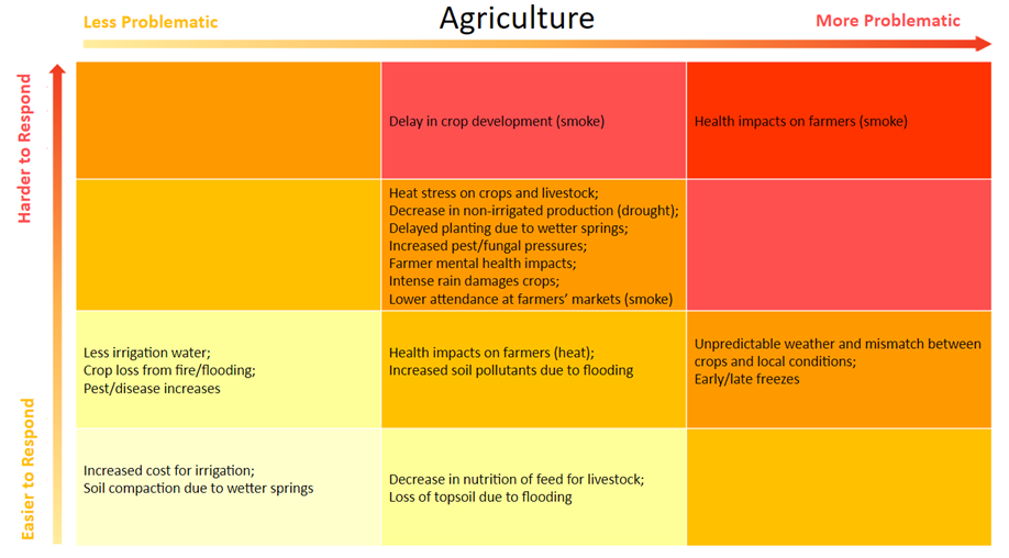
AGRICULTURE.
Wetter springs can force farmers to delay planting, which can be particularly problematic for longer season crops such as potatoes, peppers, pumpkins, and corn. In addition, the combination of milder winters and cool, wet springs create a conducive environment for many plant pathogens. Many ranchers calve or lamb in late winter/early spring, and wetter conditions are also conducive to livestock diseases, particularly those transmitted through water or by waterfowl.
Producers will need to be more vigilant to avoid soil compaction, since too much traffic on wet soil can do long-term damage to soil structure. Intense rain events can damage annual crops and alfalfa. Flooding can cause crop loss as well as topsoil loss, which is a particular problem for annual crops. In addition, pollutants in floodwater can be absorbed by crops, posing health risks to consumers and wildlife. Spring flooding can also cause ranchers to have to move their livestock out of valley bottoms and onto summer pastures in the uplands sooner, which can decrease grass/forage production if animals are released onto pastures too soon.
The full vulnerability grid for Agriculture, for all hazards, is shown below.
aquatic systems.
More frequent and severe flooding will change the quality of instream habitats through increased erosion and sediment transport. While small and infrequent flooding is important for aquatic species by moving sediment and forming instream habitat features such as pools and riffles, intense and frequent flooding events can have negative impacts on aquatic ecosystems by not allowing for recovery and adaptation. Increased flooding also increases the risk of contamination for downstream communities. Furthermore, invasive aquatic species can thrive when floodplains and river systems are disturbed because they can outcompete native species in recovery.
When rivers flood more regularly than is natural they can move too much sediment along the river bed which scours the channel bottom and increases the distance from the bottom of the channel to the top of the stream bank. This disconnects the stream system from its floodplain, which reduces soil water storage, wetland and riparian function, and enhances velocity of flows within the river banks. This, in turn, further scours the channel bottom and disconnects the river.
The full vulnerability grid for Aquatic Systems, for all hazards, is shown below.

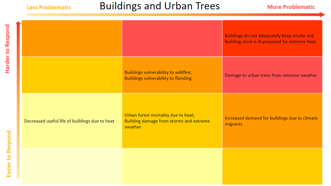
buildings and landscaping.
Flooding can damage or destroy buildings in the floodplain, which are often lower-income neighborhoods, including manufactured homes, whose residents have limited resources to rebuild their lives. Buildings and urban trees can all be damaged by snow load, wind, and stormwater associated with extreme weather events. Deciduous trees and shrubs are particularly susceptible to late season snowstorms, after leaf-out.
The full vulnerability grid for Buildings and Landscaping, for all hazards, is shown below.
The full vulnerability grid for Buildings and Landscaping, for all hazards, is shown below.
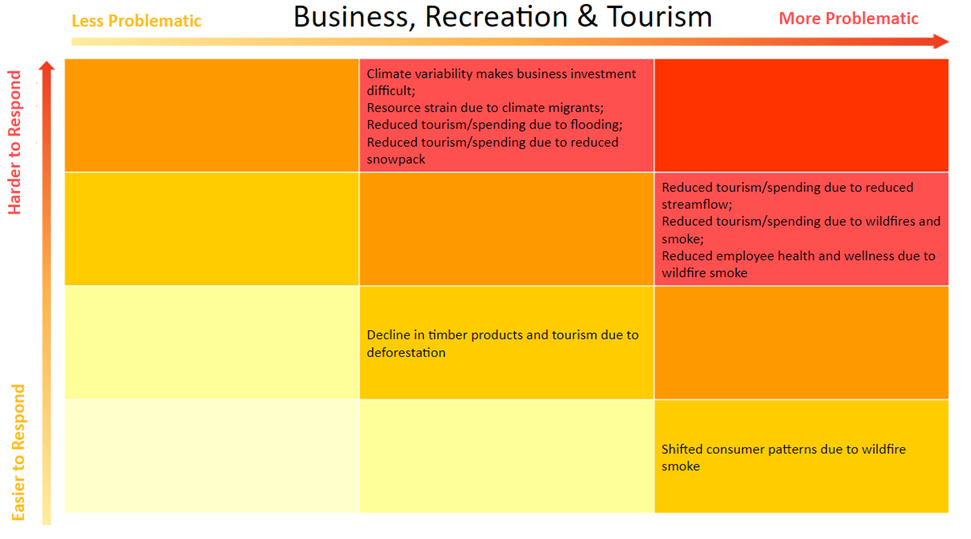
business, recreation, and tourism.
Flooding directly affects the economy by damaging homes, businesses, infrastructure, and community resources in flooded areas. Flooding also impacts the tourism and recreation industries by limiting opportunities for river-based activities such fishing, rafting and kayaking.
The full vulnerability grid for Business, Recreation, and Tourism, for all hazards, is shown below.
The full vulnerability grid for Business, Recreation, and Tourism, for all hazards, is shown below.
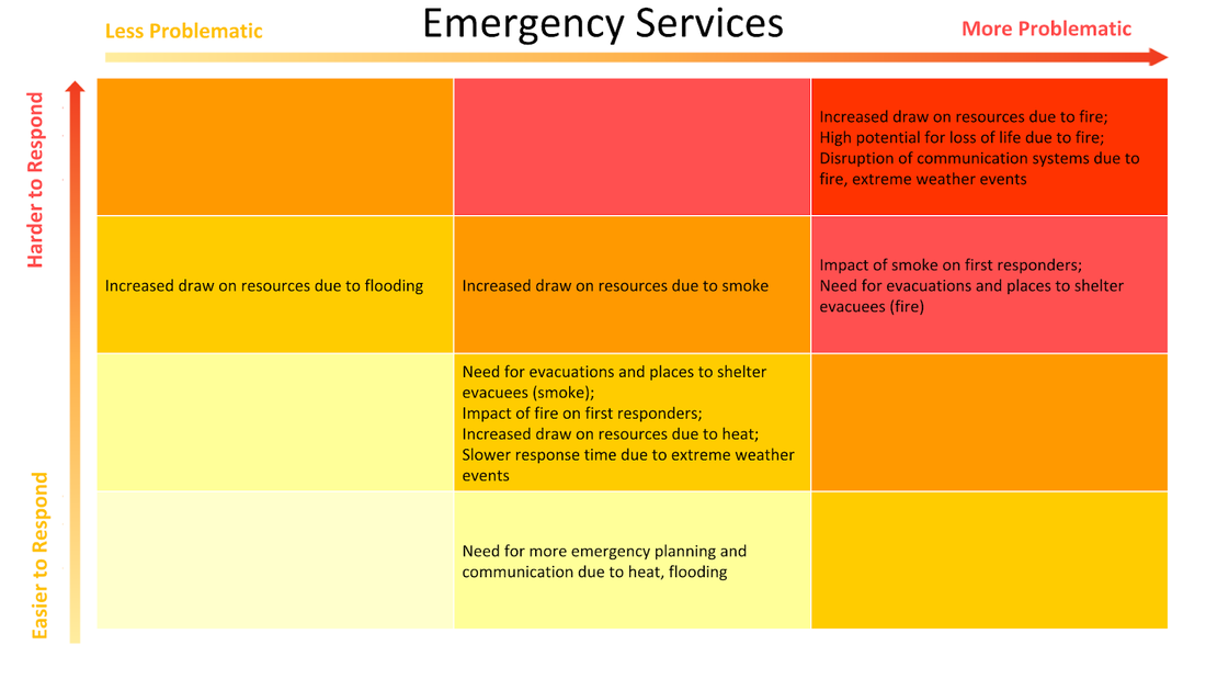
emergency preparedness and response.
Missoula County has had six federal disaster declarations for flooding since 1974, including in 2018. Property damage from flooding events in the county between 1969 and 2011 exceeded $14 million. More flooding will require more emergency planning and communication and will increase the demand on emergency responders (e.g. evacuation and rescue), all of which will strain limited resources.
Flooding and extreme weather events (severe storms and associated winds) can disrupt transportation and communication systems such as roads, bridges, sidewalks, telephone lines, and cell towers, making emergency response more difficult and increasing response time. This is especially problematic in remote rural areas. For example, some portions of Missoula County have limited cell service, only one major access road, and limited electrical infrastructure, which could all be disrupted simultaneously, leaving residents stranded and without power or means of communication.
The full vulnerability grid for Emergency Preparedness and Response, for all hazards, is shown below.
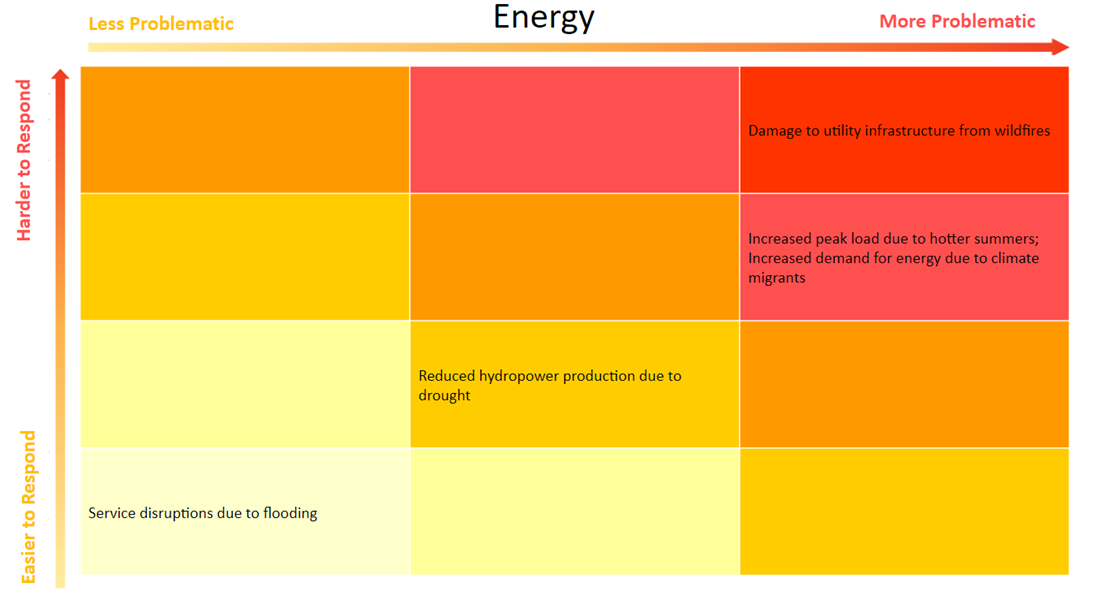
energy.
Flooding can affect power lines and lead to electric service disruptions.
The full vulnerability grid for Energy, for all hazards, is shown below.
The full vulnerability grid for Energy, for all hazards, is shown below.
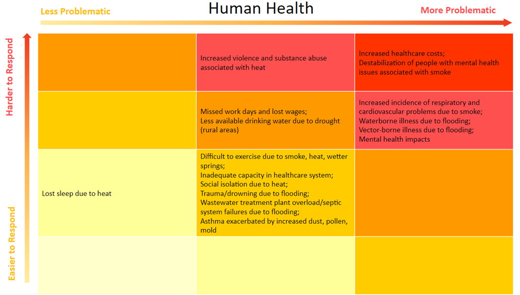
human health.
In an immediate sense, flooding can lead to drowning and physical trauma. In addition, contact with floodwater increases the risk of waterborne illness. Flooding can also lead to wastewater treatment plant overload and septic system failure, further increasing the risk of waterborne illness. Standing water breeds mosquitoes, increasing the risk of vector-borne illnesses like West Nile virus. Mold is a major health concern in buildings that have been flooded, and can lead to respiratory problems and exacerbate existing conditions such as asthma. Wetter springs also encourage mold growth as well as leading to more pollen, which can likewise exacerbate respiratory problems and allergies.
Flooding can damage homes and property and can cause people to miss school and work and to lose wages. These economic impacts can lead to health problems by increasing stress and anxiety and by preventing people from meeting their basic needs. This is particularly likely for minimum wage workers and people already experiencing financial stress.
Wetter springs make exercising outdoors more difficult, with potential long-term health impacts, especially for people without gym memberships or other opportunities to exercise indoors.
The full vulnerability grid for Human Health, for all hazards, is shown below.
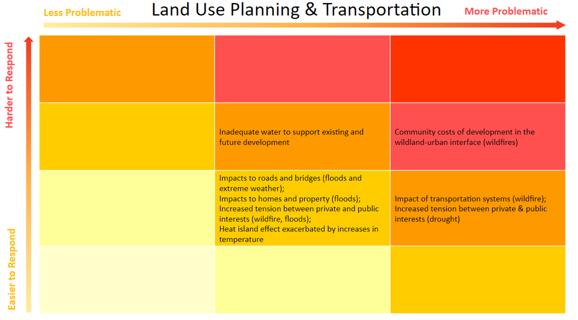
land use planning and transportation.
Flooding and extreme precipitation events impact homes and property, as well as transportation systems (roads and bridges). Areas with single road access are particularly vulnerable.
Missoula City and County generally require development within the designated floodplain to have its lowest floors two feet above the 100-year flood elevation. According to FEMA floodplain maps adopted by Missoula City and County in 2015, 1.8 percent of county land area lies within the 100-year flood hazard area, including 362 residences, 35 commercial, industrial and agricultural buildings, and 3 critical facilities. However, FEMA floodplain boundaries and projected 100-year flood elevations are based on 50-year-old hydrologic and hydraulic analyses which do not account for climate change projections.
Increased flooding will lead to increased tension between the public and private good, as local government will need to make difficult decisions weighing the rights of individuals against the cost to society of development in areas that may be at risk of flood.
The full vulnerability grid for Land Use Planning and Transportation, for all hazards, is shown below.
water infrastructure.
Floods cause short term damage to water infrastructure, such as levees, as well as long term damage from repeated stress that affects water quality and availability. Low-lying areas and communities without adequate stormwater systems are particularly vulnerable. Private and 17 smaller well systems are at risk of contamination. Increased wastewater treatment plant peak flows from flooding can cause damage to the treatment plant itself and result in contaminated water.
The full vulnerability grid for Water Infrastructure, for all hazards, is shown below.
The full vulnerability grid for Water Infrastructure, for all hazards, is shown below.