As Missoula County’s climate warms and as summers become drier, wildfires are likely to increase in size and frequency and the fire season is likely to become longer.
Wildfire is a naturally occurring phenomenon, and many ecosystems rely on fire at regular intervals to clear the forest floor, kill disease, and allow new plants to establish. In our region, the frequency and severity of fires vary over forest types and location. Over the last century, the policy of attempting to suppress wildfires has, in some areas, resulted in denser forests that, when they burn, do so much more intensely and destructively than they might have in the past. At the same time, expansion of the Wildland-Urban Interface (WUI) and increased development in the WUI put more people and structures at risk from wildfire.
How will wildfires impact Missoula County?
Explore how wildfires create vulnerabilities in the following sectors given climate change:
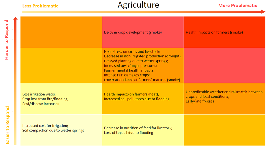
AGRICULTURE.
Agricultural producers, in particular pasture lease-holders on forest lands, will be at increased risk of crop loss from fire.
The full vulnerability grid for Agriculture, for all hazards, is shown below.
The full vulnerability grid for Agriculture, for all hazards, is shown below.
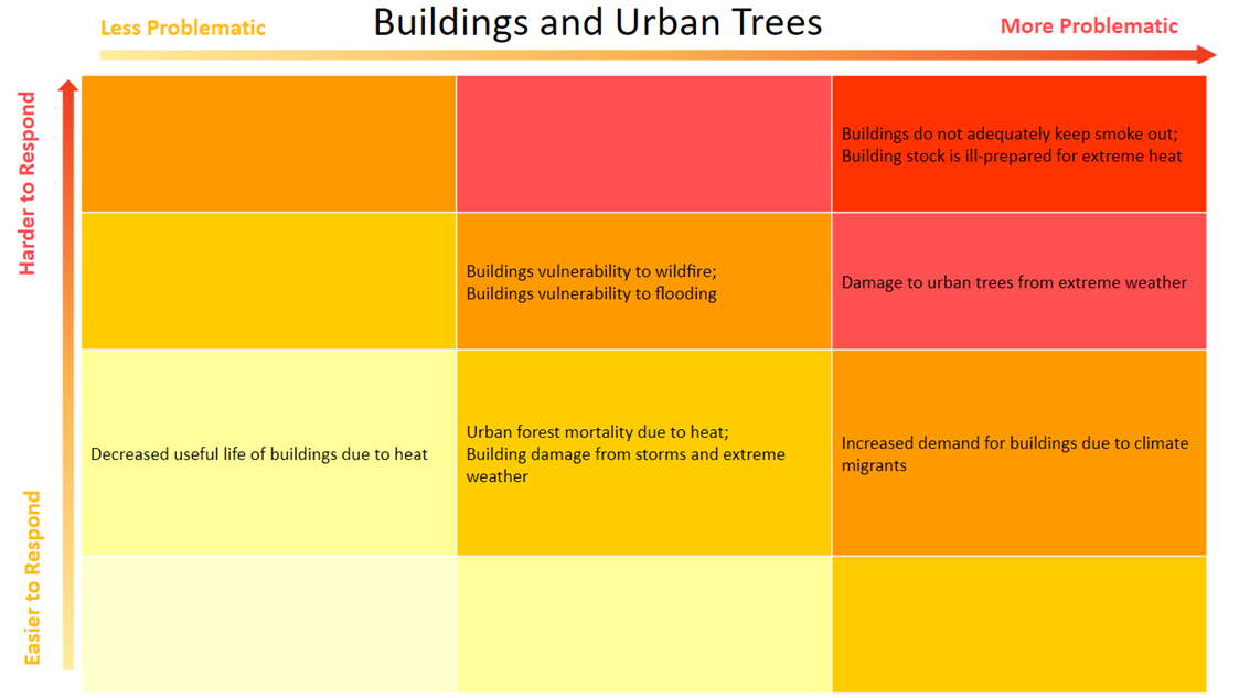
buildings and landscaping.
The vulnerability of a building to being destroyed by wildfire depends on where the building is located, the surrounding landscaping, and construction of the building itself. In terms of location, buildings in the WUI are at greatest risk.
The full vulnerability grid for Buildings and Landscaping, for all hazards, is shown below.
The full vulnerability grid for Buildings and Landscaping, for all hazards, is shown below.
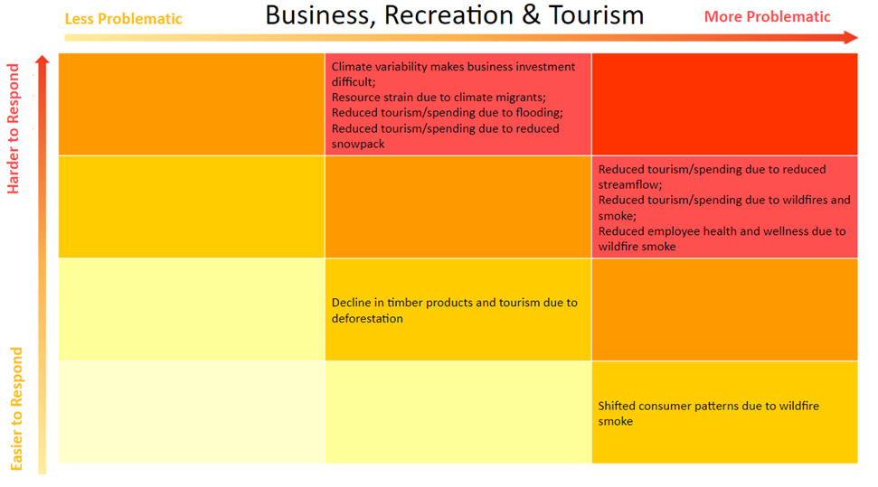
business, recreation, and tourism.
Wildfires have direct economic impacts through property loss and firefighting costs. They also limit opportunities for outdoor recreation both directly – in areas affected by fire – as well as indirectly, by reducing air quality over a much larger geographic area (see Wildfire Smoke).
The full vulnerability grid for Business, Recreation, and Tourism, for all hazards, is shown below.
The full vulnerability grid for Business, Recreation, and Tourism, for all hazards, is shown below.
emergency preparedness and response.
Addressing more frequent and intense wildfires—and the associated potential for loss of life—is likely to be the greatest climate-related challenge for Missoula City and County emergency services. Rural parts of the county that face the greatest wildfire threat are served by a combination of paid and volunteer firefighters, and volunteer fire departments throughout the county are understaffed and shrinking.
Larger fires and longer fire seasons, combined with continued development in the WUI, will increasingly strain these limited resources and increase the need for emergency planning and communication. More fires will also increase personal risk to firefighters. In addition to firefighting, there will be increased need to coordinate evacuations and shelter evacuees. Loss or disruption of communication systems, particularly cell phone service, has the potential to compound the difficulty of responding to wildfire by making it more difficult to notify affected residents.
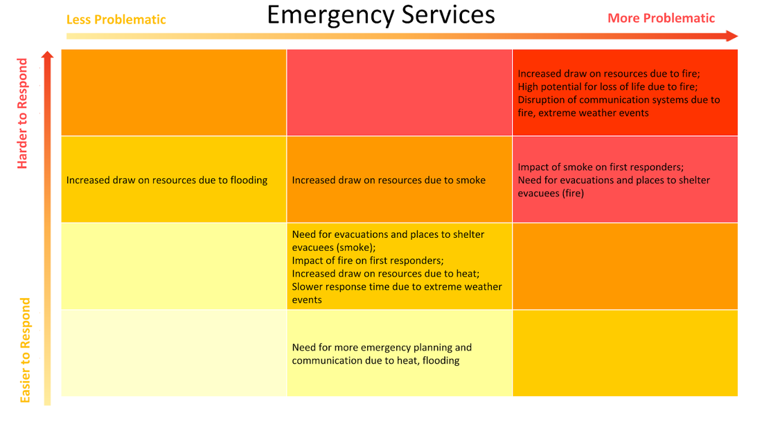
The full vulnerability grid for Emergency Preparedness and Response, for all hazards, is shown below.
Larger fires and longer fire seasons, combined with continued development in the WUI, will increasingly strain these limited resources and increase the need for emergency planning and communication. More fires will also increase personal risk to firefighters. In addition to firefighting, there will be increased need to coordinate evacuations and shelter evacuees. Loss or disruption of communication systems, particularly cell phone service, has the potential to compound the difficulty of responding to wildfire by making it more difficult to notify affected residents.
The full vulnerability grid for Emergency Preparedness and Response, for all hazards, is shown below.
energy.
Utility infrastructure has the potential to start wildfires, and also to be damaged by fire, causing service disruptions for utility customers. Residents of the WUI are most likely to be affected by these outages, though infrastructure damage could result in large scale outages affecting much of the city and county.
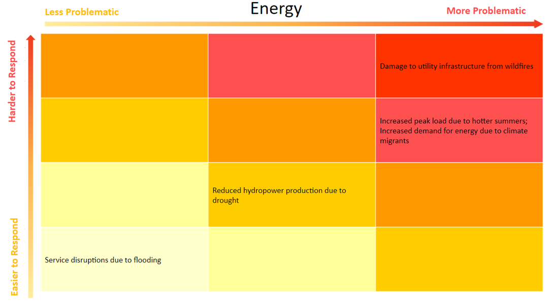
The full vulnerability grid for Energy, for all hazards, is shown below.
The full vulnerability grid for Energy, for all hazards, is shown below.
forest and terrestrial ecosystems.
Over time the size and severity of wildfires will likely impact the ability of forests to recover after fires, leading to a transition from forests to grasslands or shrublands at low elevations. Terrestrial invasive species thrive in areas that have been recently disturbed by wildfires and will likely expand their range in the county. Increased erosion and soil loss will result from rain following wildfires.
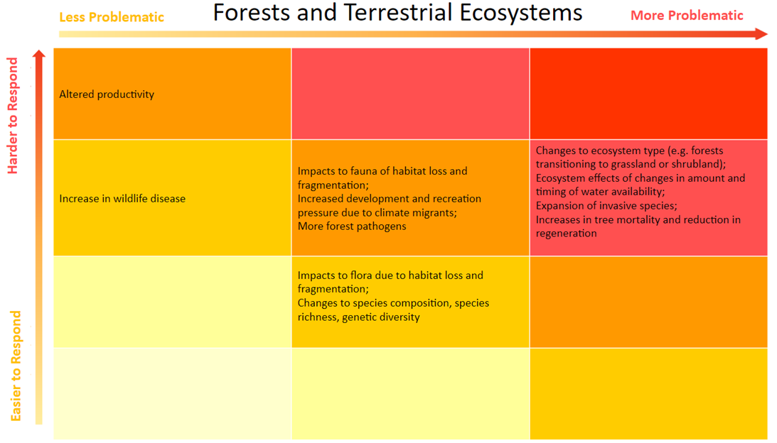
The full vulnerability grid for Forest and Terrestrial Ecosystems, for all hazards, is shown below.
The full vulnerability grid for Forest and Terrestrial Ecosystems, for all hazards, is shown below.
human health.
In addition to the far-reaching health impacts of wildfire smoke, wildfires themselves are a direct threat to the health and safety of people in affected areas. People who live in the WUI are at greatest risk of burns and trauma, as are firefighters and other first responders. Survivors of traumatic events such as wildfires are at risk of mental health impacts such as anxiety and depression. In addition, fires can damage homes and property and cause people to miss school and work and to lose wages. These economic impacts can lead to health problems by further increasing anxiety and stress and/or by preventing people from meeting their basic needs. This is particularly likely for minimum wage workers and people already experiencing financial stress.
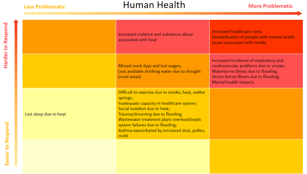
The full vulnerability grid for Human Health, for all hazards, is shown below.
The full vulnerability grid for Human Health, for all hazards, is shown below.
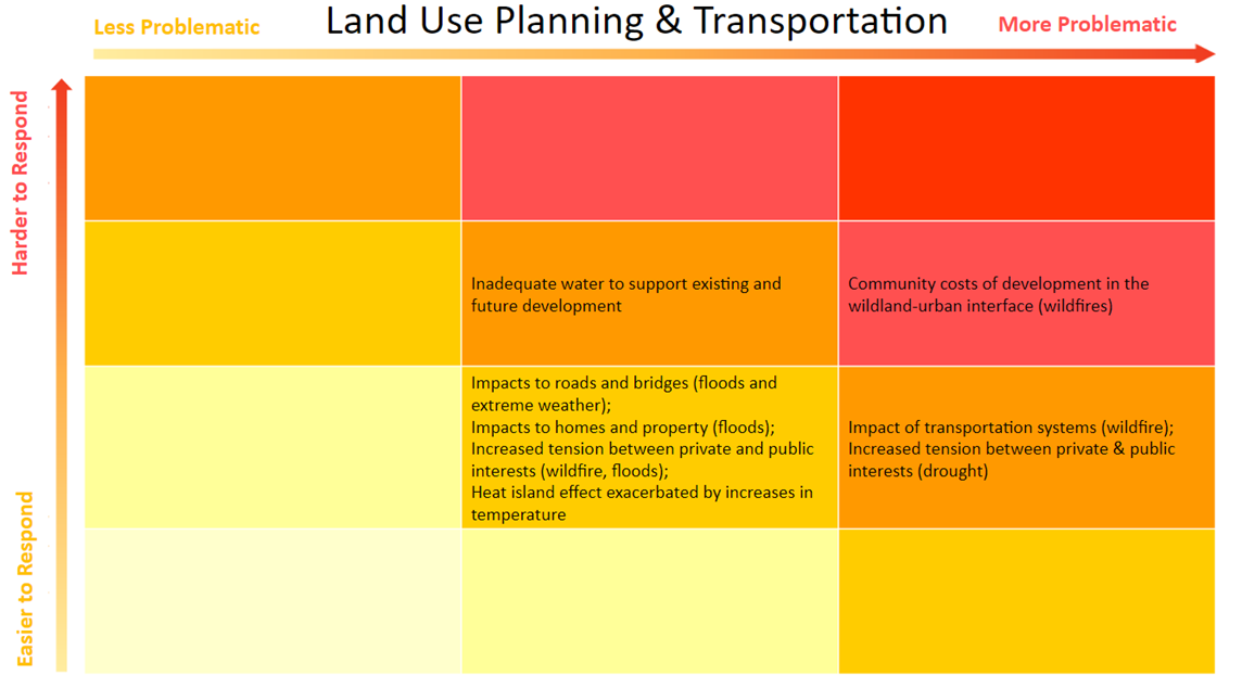
land use planning and transportation.
Nearly all the development in Missoula County outside of the urban core is within the WUI and therefore particularly vulnerable to wildfire. As the county population expands and wildfire risk continues to increase, there will be increasing tension between private interests and the public good. For example, the rights of individuals to build their homes where they’d like may directly increase the cost to society of protecting those homes when they are threatened by wildfire.
Transportation systems are also impacted by wildfire, which is a particular problem for people in rural areas who are dependent on a single transportation route for evacuation, commerce, and emergency response.
The full vulnerability grid for Land Use Planning and Transportation, for all hazards, is shown below.
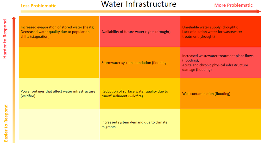
water infrastructure.
Wildfires lead to soil erosion by destroying vegetation that limits runoff and damaging the soil’s ability to absorb water. Eroded soil and ash flow into streams and rivers, degrading surface water quality. This is an issue for parts of Missoula County, such as the Seeley Lake area, that rely on surface water for their drinking water. Loss of power from damaged power lines also poses a risk to water infrastructure (pumping) in rural communities and areas without power redundancy.
The full vulnerability grid for Water Infrastructure, for all hazards, is shown below.
The full vulnerability grid for Water Infrastructure, for all hazards, is shown below.